Global ecosystem typology
Alternative site for the Global ecosystem typology with additional information for ecosystem profiles and indicative maps.
This site is maintained by jrfep
F2.8 Artesian springs and oases
Biome: F2. Lakes biome
Contributors:
(texts)
Surface waterbodies fed by (often warm) groundwaters rising to the surface are scattered in dry landscapes of Africa, the Middle East, Eurasia, North America and Australia, but also occur in humid landscapes. Algae, floating plants and leaf fall support waterbugs, crustaceans and small fish making simple foodwebs with some locally restricted species found nowhere else. These ecosystems are sometimes important waterholes for birds and mammals, in otherwise dry landscapes.
Key Features
Groundwater dependent ecosystems from artesian waters discharged to the surface, maintaining relatively stable water levels. Often insular systems with high endemism.
Overview of distribution
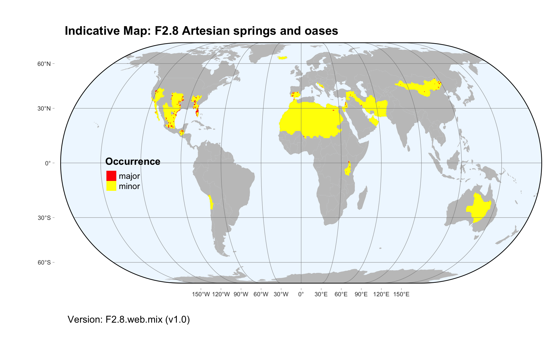
Mostly in arid regions in Africa, the Middle East, central Eurasia, southwest of North America and Australia’s Great Artesian basin.
Profile versions
- v1.0 (2020-01-20): DJ Roux; RT Kingsford; DA Keith
- v2.0 (2020-05-26): DJ Roux; RT Kingsford; AH Arthington; DA Keith
- v2.01 ():
- v2.1 (2022-04-06): DJ Roux; RT Kingsford; AH Arthington; DA Keith Full profile available at official site
Main references
Selected references for this functional group:
Patten DT, Rouse L, Stromberg JC (2008) Isolated spring wetlands in the Great Basin and Mojave Deserts, USA: potential response of vegetation to groundwater withdrawal Environmental Management 41: 398-413
Worthington Wilmer J, Elkin C, Wilcox C, Murray L, Niejalke D, Possingham H (2008) The influence of multiple dispersal mechanisms and landscape structure on population clustering and connectivity in fragmented artesian spring snail populations Molecular Ecology 17: 3733-3751
Rossini R, Fensham R, Stewart-Koster B, Gotch T, Kennard M (2018) Biographical patterns of endemic diversity and its conservation in Australia’s artesian desert springs Diversity and Distributions 24, 1-18 DOI:10.1111/ddi.12757
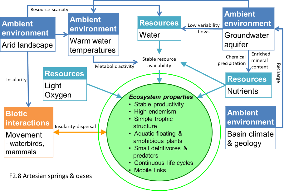
Diagrammatic assembly model

Maps
Maps are indicative of global distribution patterns are not intended to represent fine-scale patterns. The maps show areas of the world containing major (coloured red) or minor occurrences (coloured yellow) of each ecosystem functional group. See general notes on maps.
There are 2 alternative versions of the indicative map for this functional group, please compare description and sources below.
F2.8.IM.mix_v1.0
Datasets
- GSW-1.1
- FEOW-2008
- HydroLAKES-1.0
Map references
Pekel JF, Cottam A, Gorelick N, Belward AS (2016) High-resolution mapping of global surface water and its long-term changes Nature 540, 418-422 DOI:10.1038/nature20584
Abell R, Thieme ML, Revenga C, Bryer M, Kottelat M, Bogutskaya N, Coad B, Mandrak N, Contreras Balderas S, Bussing W, Stiassny MLJ, Skelton P, Allen GR, Unmack P, Naseka A, Ng R, Sindorf N, Robertson J, Armijo E, Higgins JV, Heibel TJ, Wikramanayake E, Olson D, López HL, Reis RE, Lundberg JG, Sabaj Pérez MH, Petry P (2008) Freshwater ecoregions of the world: A new map of biogeographic units for freshwater biodiversity conservation, BioScience 58: 403–414. DOI:10.1641/B580507
Messager, M.L., Lehner, B., Grill, G., Nedeva, I., Schmitt, O. (2016) Estimating the volume and age of water stored in global lakes using a geo-statistical approach Nature Communications 13603 DOI:10.1038/ncomms13603
F2.8.web.mix_v1.0

Datasets
- FEOW-2008
- GSW-1.1
- HydroLAKES-1.0
Map references
Abell R, Thieme ML, Revenga C, Bryer M, Kottelat M, Bogutskaya N, Coad B, Mandrak N, Contreras Balderas S, Bussing W, Stiassny MLJ, Skelton P, Allen GR, Unmack P, Naseka A, Ng R, Sindorf N, Robertson J, Armijo E, Higgins JV, Heibel TJ, Wikramanayake E, Olson D, López HL, Reis RE, Lundberg JG, Sabaj Pérez MH, Petry P (2008) Freshwater ecoregions of the world: A new map of biogeographic units for freshwater biodiversity conservation, BioScience 58: 403–414. DOI:10.1641/B580507
Pekel JF, Cottam A, Gorelick N, Belward AS (2016) High-resolution mapping of global surface water and its long-term changes Nature 540, 418-422 DOI:10.1038/nature20584
Messager, M.L., Lehner, B., Grill, G., Nedeva, I., Schmitt, O. (2016) Estimating the volume and age of water stored in global lakes using a geo-statistical approach Nature Communications 13603 DOI:10.1038/ncomms13603
Check: the Glossary / Profile structure / the public document