Global ecosystem typology
Alternative site for the Global ecosystem typology with additional information for ecosystem profiles and indicative maps.
This site is maintained by jrfep
F3.2 Constructed lacustrine wetlands
Biome: F3. Artificial wetlands biome
Contributors:
(texts)
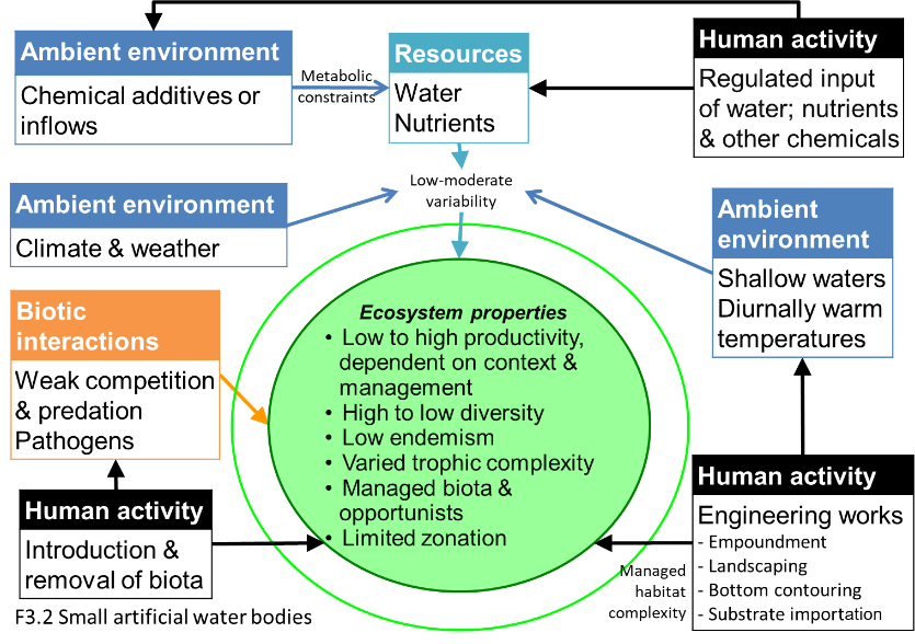
Small farm dams, wastewater ponds and mine pits generally form lake-like environments, common in humid and semi-arid climates world-wide. Nutrient inputs vary greatly depending on purpose and surrounding land uses. They are often warm and shallow, and biological productivity and diversity vary widely depending on the cover and state of fringing vegetation, with the most diverse examples rivalling equivalent natural wetlands. Aquatic plants, plankton, algae and waterbugs may dominate in the shallows, supporting amphibians, turtles, fish, and waterbirds.
Key Features
Small, shallow open waterbodies with high or low productivity depending on nutrient subsidies and complexity of littoral zones and benthos Relatively simple trophic networks with algae, macrophytes, zooplankton, aquatic invertebrates and amphibians.
Overview of distribution
Scattered across all regions of the world.
Profile versions
- v1.0 (2020-01-20): JL Nel; RT Kingsford; LJ Jackson; DA Keith
- v2.0 (2020-06-01): JL Nel; RT Kingsford; B Robson; M Kelly-Quinn; LJ Jackson; R Harper; DA Keith
- v2.01 ():
- v2.1 (2022-04-06): JL Nel; RT Kingsford; B Robson; M Kelly-Quinn; LJ Jackson; R Harper; DA Keith Full profile available at official site
Main references
Selected references for this functional group:
Downing JA, Prairie YT, Cole JJ, Duarte CM, Tranvik LJ, Striegl RG, McDowell WH, Kortelainen P, Caraco NF, Melack JM, Middelburg JJ (2006) The global abundance and size distribution of lakes, ponds, and impoundments Limnology and Oceanography 51: 2388-2397 DOI:10.4319/lo.2006.51.5.2388
Kloskowski J, Green AJ, Polak M, Bustamante J, Krogulec J (2009) Complementary use of natural and artificial wetlands by waterbirds wintering in Doñana, south‐west Spain Aquatic Conservation: Marine and Freshwater Ecosystems 19: 815-826 DOI:10.1002/aqc.1027
Chester ET, Robson BJ (2013) Anthropogenic refuges for freshwater biodiversity: Their ecological characteristics and management Biological Conservation 166: 64 – 75 DOI:10.1016/j.biocon.2013.06.016
Diagrammatic assembly model

Maps
Maps are indicative of global distribution patterns are not intended to represent fine-scale patterns. The maps show areas of the world containing major (coloured red) or minor occurrences (coloured yellow) of each ecosystem functional group. See general notes on maps.
Information about the current valid indicative map for this functional group is shown below.
F3.2.WM.nwx_v1.0
Datasets
- EarthStat-Crops
- HydroLAKES-1.0
Map references
Ramankutty, N., A.T. Evan, C. Monfreda, and J.A. Foley (2008) Farming the planet: 1. Geographic distribution of global agricultural lands in the year 2000 Global Biogeochemical Cycles 22, GB1003 DOI:10.1029/2007GB002952
Messager, M.L., Lehner, B., Grill, G., Nedeva, I., Schmitt, O. (2016) Estimating the volume and age of water stored in global lakes using a geo-statistical approach Nature Communications 13603 DOI:10.1038/ncomms13603
Check: the Glossary / Profile structure / the public document