Global ecosystem typology
Alternative site for the Global ecosystem typology with additional information for ecosystem profiles and indicative maps.
This site is maintained by jrfep
FM1.1 Deepwater coastal inlets
Biome: FM1. Semi-confined transitional waters biome
Contributors:
(texts)
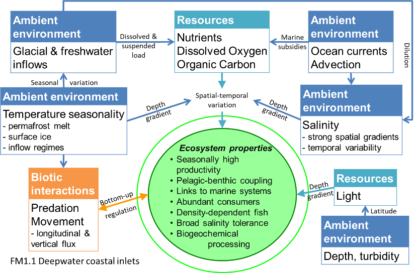
Ecosystems in these deep, narrow inlets were mostly formed by glaciers and subsequently flooded (e.g. fjords). They have some features of open oceans, but are strongly influenced by freshwater inflows and the surrounding coast. Productivity by phytoplankton is seasonal and limited by cold, dark winters. Oxygen may be limited in the deepest parts of these systems. The diverse biota includes invertebrates and fish, such as jellyfish and salmon, and predatory marine mammals such as killer whales.
Key Features
Strong gradients between adjacent terrestrial and freshwater systems,e.g. fjords. Seasonaly abundant plankton, jellies, fish and mammals..
Overview of distribution
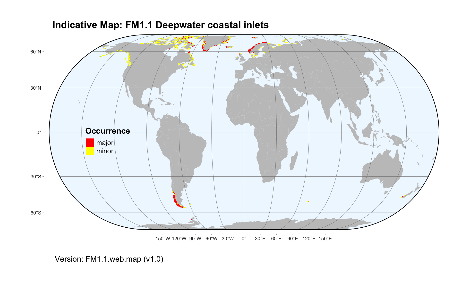
Glaciated coastlines (current or historical) in polar or cool-temperate regions.
Profile versions
- v1.0 (2020-01-20): DA Keith; EJ Gregr; A Lindgaard
- v2.0 (2020-05-27): DA Keith; EJ Gregr; A Lindgaard; TS Bianchi
- v2.01 ():
- v2.1 (2022-04-06): DA Keith; EJ Gregr; A Lindgaard; TS Bianchi Full profile available at official site
Main references
Selected references for this functional group:
Salvanes AGV (2001) Review of ecosystem models of fjords; new insights of relevance to fisheries management Sarsia 86:441-463
Zaborska A, Włodarska-Kowalczuk M, Legeżyńska J et al. (2018) Sedimentary organic matter sources, benthic consumption and burial in west Spitsbergen fjords – Signs of maturing of Arctic fjordic systems? Journal of Marine Systems 180: 112–123
Bianchi TS, Arndt S, Austin WEN, Benn DI, Bertrand S, Cui X, Faust JC, Koziorowska-Makuch K, Moy CM, Savage C, Smeaton C, Smith RW, Syvitski J (2020) Fjords as Aquatic Critical Zones (ACZs) Earth-Science Reviews 203, 103145 DOI:10.1016/j.earscirev.2020.103145
Diagrammatic assembly model

Maps
Maps are indicative of global distribution patterns are not intended to represent fine-scale patterns. The maps show areas of the world containing major (coloured red) or minor occurrences (coloured yellow) of each ecosystem functional group. See general notes on maps.
There are 2 alternative versions of the indicative map for this functional group, please compare description and sources below.
FM1.1.IM.alt_v3.0
Datasets
- SRTM30-PLUS-V11
- Coastal-Typology-2011
- GeoNames-2020
- SCAR-gazetteer-2020
Map references
Becker JJ, Sandwell DT, Smith WHF, Braud J, Binder B, Depner J, Fabre D, Factor J, Ingalls S, Kim S-H, Ladner R, Marks K, Nelson S, Pharaoh A, Trimmer R, Von Rosenberg J, Wallace G, Weatherall P (2009) Global Bathymetry and Elevation Data at 30 Arc Seconds Resolution: SRTM30_PLUS, Marine Geodesy 32: 355-371. DOI:10.1080/01490410903297766
Dürr, H. H., G. G. Laruelle, C. M. van Kempen, C. P. Slomp, M. Meybeck and H. Middelkoop (2011) Worldwide Typology of Nearshore Coastal Systems: Defining the Estuarine Filter of River Inputs to the Oceans Estuaries and Coasts 34(3), 441-458 DOI:10.1007/s12237-011-9381-y
GeoNames (2020) The GeoNames geographical database [https://www.geonames.org] Accessed in Feb 2020
Secretariat SCAR (1992, updated 2020). Composite Gazetteer of Antarctica, Scientific Committee on Antarctic Research. GCMD Metadata
FM1.1.web.map_v1.0

Datasets
- SRTM30-PLUS-V11
- Coastal-Typology-2011
- GeoNames-2020
- SCAR-gazetteer-2020
Map references
Becker JJ, Sandwell DT, Smith WHF, Braud J, Binder B, Depner J, Fabre D, Factor J, Ingalls S, Kim S-H, Ladner R, Marks K, Nelson S, Pharaoh A, Trimmer R, Von Rosenberg J, Wallace G, Weatherall P (2009) Global Bathymetry and Elevation Data at 30 Arc Seconds Resolution: SRTM30_PLUS, Marine Geodesy 32: 355-371. DOI:10.1080/01490410903297766
Dürr, H. H., G. G. Laruelle, C. M. van Kempen, C. P. Slomp, M. Meybeck and H. Middelkoop (2011) Worldwide Typology of Nearshore Coastal Systems: Defining the Estuarine Filter of River Inputs to the Oceans Estuaries and Coasts 34(3), 441-458 DOI:10.1007/s12237-011-9381-y
GeoNames (2020) The GeoNames geographical database [https://www.geonames.org] Accessed in Feb 2020
Secretariat SCAR (1992, updated 2020). Composite Gazetteer of Antarctica, Scientific Committee on Antarctic Research. GCMD Metadata
Check: the Glossary / Profile structure / the public document