Global ecosystem typology
Alternative site for the Global ecosystem typology with additional information for ecosystem profiles and indicative maps.
This site is maintained by jrfep
T7.2 Sown pastures and fields
Biome: T7. Intensive land-use biome
Contributors:
(texts)
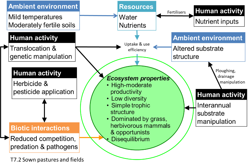
In these intensively managed agricultural systems, grasses and legumes are sown and cultivated, with regular inputs of nutrients and (sometimes) water, primary for the mostly commercial production of livestock or food (hay) for livestock. Sown pastures are structurally simple ecosystems with low-diversity and high-productivity. They are dominated by one or few selected plant species as primary food sources for one animal species (usually large mammalian herbivores). Management includes chemical or physical treatments to exclude competitors, predators, herbivores, or pathogens. They differ from less intensively managed rangeland (e.g. biome T5) and semi-natural grasslands (T7.5), where livestock graze in predominantly native ecosystems.
Key Features
Structurally simple, very low- diversity, high-productivity grasslands dominated by one or few species of perennial grasses (Poacaeae) maintained by intensive addition of nutrients, water and artificial disturbance regimes (mowing or grazing).
Overview of distribution
Abundant in humid or sub-humid, boreal to tropical climates worldwide.
Profile versions
- v1.0 (2020-01-20): DA Keith
- v2.0 (2020-05-31): DA Keith; R Harper
- v2.01 ():
- v2.1 (2022-04-06): DA Keith; R Harper Full profile available at official site
Main references
Selected references for this functional group:
Spedding CRW (1986) Animal production from grass: A systems approach Bioindustrial ecosystems (Eds. DAJ Cole, GC Brander), pp 107-120. Ecosystems of the world vol. 21. Elsevier, Amsterdam
Bernués A, Ruiz R, Olaizola A, Villalba D, Casasús I (2011) Sustainability of pasture-based livestock farming systems in the European Mediterranean context: Synergies and trade-offs Livestock Science 139: 44–57
Diagrammatic assembly model

Maps
Maps are indicative of global distribution patterns are not intended to represent fine-scale patterns. The maps show areas of the world containing major (coloured red) or minor occurrences (coloured yellow) of each ecosystem functional group. See general notes on maps.
Information about the current valid indicative map for this functional group is shown below.
T7.2.WM.nwx_v1.0
Datasets
- GLW3-lifestock-2010
- HANPP-Haberl
- EarthStat-Crops
Map references
Gilbert M, G Nicolas, G Cinardi, S Vanwambeke, TP Van Boeckel, GRW Wint, TP Robinson (2018) Global Distribution Data for Cattle, Buffaloes, Horses, Sheep, Goats, Pigs, Chickens and Ducks in 2010 Nature Scientific data 5:180227 DOI:10.1038/sdata.2018.227
Helmut Haberl, K. Heinz Erb, Fridolin Krausmann, Veronika Gaube, Alberte Bondeau, Christoph Plutzar, Simone Gingrich, Wolfgang Lucht, Marina Fischer-Kowalski (2007) Quantifying and mapping the human appropriation of net primary production in earth’s terrestrial ecosystems Proceedings of the National Academy of Sciences 104 (31) 12942-12947 DOI:10.1073/pnas.0704243104
Ramankutty, N., A.T. Evan, C. Monfreda, and J.A. Foley (2008) Farming the planet: 1. Geographic distribution of global agricultural lands in the year 2000 Global Biogeochemical Cycles 22, GB1003 DOI:10.1029/2007GB002952
Check: the Glossary / Profile structure / the public document