Global ecosystem typology
Alternative site for the Global ecosystem typology with additional information for ecosystem profiles and indicative maps.
This site is maintained by jrfep
T7.4 Urban and industrial ecosystems
Biome: T7. Intensive land-use biome
Contributors:
(texts)
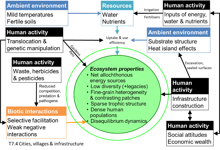
Cities, smaller settlements and industrial areas are structurally complex ecosystems and characterised by their highly dynamic spatial structure. Diverse patch types include buildings, paved surfaces, transport infrastructure, parks and gardens; excavations, bare ground and refuse areas. Patches undergo periodic destruction and renewal. Human population density is high, relative to other ecosystems, and dependent on large subsidies of imported resources (particularly water, nutrients and food). Interactions among patch types and human social behaviours produce emergent properties and complex feedbacks among ecosystem components.
Key Features
Ecosystems dominated by anthroipogenic structures (e.g. buildings, roads, wastelands) associated with human infrastructures, intensive anthropogenic disturbance regimes, and severely altered biogeochemical site conditions.
Overview of distribution
Abundant worldwide in all regions settled by humans.
Profile versions
- v1.0 (2020-01-20):
- v2.0 (2020-05-31): DA Keith; RT Corlett
- v2.01 ():
- v2.1 (2022-04-06): DA Keith; RT Corlett Full profile available at official site
Main references
Selected references for this functional group:
Alberti M, Marzluff JM, Shulenberger E, Bradley G, Ryan C, Zumbrunnen C (2003) Integrating Humans into Ecology: Opportunities and Challenges for Studying Urban Ecosystems Urban Ecology (Eds. Marzluff J.M. et al.) Springer, Boston, MA DOI:10.1007/978-0-387-73412-5_9
Grimm NB, Faeth SH, Golubiewski NE, Redman CL, Wu J, Bai X, Briggs JM (2008) Global change and the ecology of cities Science 319: 756-760
Diagrammatic assembly model

Maps
Maps are indicative of global distribution patterns are not intended to represent fine-scale patterns. The maps show areas of the world containing major (coloured red) or minor occurrences (coloured yellow) of each ecosystem functional group. See general notes on maps.
Information about the current valid indicative map for this functional group is shown below.
T7.4.WM.nwx_v1.0

Datasets
- ESRI-2020-Landcover
Map references
Karra, Kontgis, et al. (2021) Global land use/land cover with Sentinel-2 and deep learning IGARSS 2021-2021 IEEE International Geoscience and Remote Sensing Symposium IEEE
Check: the Glossary / Profile structure / the public document