Global ecosystem typology
Alternative site for the Global ecosystem typology with additional information for ecosystem profiles and indicative maps.
This site is maintained by jrfep
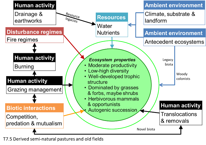
T7.5 Derived semi-natural pastures and old fields
Biome: T7. Intensive land-use biome
Contributors:
(texts)
These managed ecosystems are derived from a range of other ecosystems (mostly from biome T1 - biome T4, a few from biome T5) by the removal or modification of woody plant components. The remaining vegetation includes both local indigenous species and introduced species, providing habitat for a mixed indigenous and non-indigenous fauna. They are used mainly for livestock grazing, which is essential to maintaining the structure of the system. Unlike sown pastures, inputs of water and nutrients are limited. Although structurally simpler than the systems from which they were derived, they often harbour an appreciable diversity of native organisms.
Key Features
Extensively used, low-input grasslands (no or moderate fertilizer application, no sowing), rich in vascular plant species.
Overview of distribution
In humid or sub-humid, boreal to tropical climates worldwide, mostly in regions with long agricultural tradition (e.g. Europe, western Asia).
Profile versions
- v1.0 (2020-05-18): DA Keith
- v2.0 (2020-06-15): DA Keith; PW Bogaart
- v2.01 ():
- v2.1 (2022-04-06): DA Keith; PW Bogaart Full profile available at official site
Main references
Selected references for this functional group:
Cramer VA, Hobbs RJ, Standish RJ (2008) What’s new about old fields? Land abandonment and ecosystem assembly. Trends in Ecology & Evolution 23, 104-112.
García-Feced, Weissteiner CJ, Baraldi A, Paracchini MA, Maes J, Zulian G, Kempen M, Elbersen B, Pérez-Sob M (2015) Semi-natural vegetation in agricultural land: European map and links to ecosystem service supply. Agronomy for Sustainable Development 35, 273–283.
Krauss J, Bommarco R, Guardiola M, Heikkinen RK, Helm A, Kuussaari M, Lindborg R, Öckinger E, Pärtel M, Pino J, Pöyry J, Raatikainen KM, Sang A, Stefanescu C, Teder T, Zobel M, Steffan-Dewenter I (2010) Habitat fragmentation causes immediate and time delayed biodiversity loss at different trophic levels. Ecology Letters 13, 597–605.
Diagrammatic assembly model

Maps
Maps are indicative of global distribution patterns are not intended to represent fine-scale patterns. The maps show areas of the world containing major (coloured red) or minor occurrences (coloured yellow) of each ecosystem functional group. See general notes on maps.
Information about the current valid indicative map for this functional group is shown below.
T7.5.WM.nwx_v2.0
Datasets
- Consistent-Land-Use-2000
- HANPP-Haberl
Map references
Karl-Heinz Erb, Veronika Gaube, Fridolin Krausmann, Christoph Plutzar, Alberte Bondeau & Helmut Haberl (2007) A comprehensive global 5 min resolution land-use data set for the year 2000 consistent with national census data Journal of Land Use Science 2:3, 191-224 DOI:10.1080/17474230701622981
Helmut Haberl, K. Heinz Erb, Fridolin Krausmann, Veronika Gaube, Alberte Bondeau, Christoph Plutzar, Simone Gingrich, Wolfgang Lucht, Marina Fischer-Kowalski (2007) Quantifying and mapping the human appropriation of net primary production in earth’s terrestrial ecosystems Proceedings of the National Academy of Sciences 104 (31) 12942-12947 DOI:10.1073/pnas.0704243104
Check: the Glossary / Profile structure / the public document